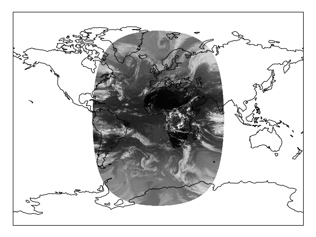
This example demonstrates Cartopy’s ability to project images into the desired projection on-the-fly. The image itself is retrieved from a URL and is loaded directly into memory without storing it intermediately into a file. It represents pre-processed data from Moderate-Resolution Imaging Spectroradiometer (MODIS) which has been put into an image in the data’s native Geostationary coordinate system - it is then projected by cartopy into a global Miller map.
"""
Reprojecting images from a Geostationary projection
---------------------------------------------------

This example demonstrates Cartopy's ability to project images into the desired
projection on-the-fly. The image itself is retrieved from a URL and is loaded
directly into memory without storing it intermediately into a file. It
represents pre-processed data from Moderate-Resolution Imaging
Spectroradiometer (MODIS) which has been put into an image in the data's
native Geostationary coordinate system - it is then projected by cartopy
into a global Miller map.

"""
try:
    from urllib2 import urlopen
except ImportError:
    from urllib.request import urlopen
from io import BytesIO

import cartopy.crs as ccrs
import matplotlib.pyplot as plt


def geos_image():
    """
    Return a specific MODIS image by retrieving it from a github gist URL.

    Returns
    -------
    img : numpy array
        The pixels of the image in a numpy array.
    img_proj : cartopy CRS
        The rectangular coordinate system of the image.
    img_extent : tuple of floats
        The extent of the image ``(x0, y0, x1, y1)`` referenced in
        the ``img_proj`` coordinate system.
    origin : str
        The origin of the image to be passed through to matplotlib's imshow.

    """
    url = ('https://gist.github.com/pelson/5871263/raw/'
           'EIDA50_201211061300_clip2.png')
    img_handle = BytesIO(urlopen(url).read())
    img = plt.imread(img_handle)
    img_proj = ccrs.Geostationary(satellite_height=35786000)
    img_extent = (-5500000, 5500000, -5500000, 5500000)
    return img, img_proj, img_extent, 'upper'


def main():
    ax = plt.axes(projection=ccrs.Miller())
    ax.coastlines()
    ax.set_global()
    img, crs, extent, origin = geos_image()
    plt.imshow(img, transform=crs, extent=extent, origin=origin, cmap='gray')
    plt.show()


if __name__ == '__main__':
    main()