Previous topic
Cartopy matplotlib integration reference document
Next topic
This Page
Quick search
Enter search terms or a module, class or function name.
The Gridliner instance, often created by calling the cartopy.mpl.geoaxes.GeoAxes.gridlines() method on a cartopy.mpl.geoaxes.GeoAxes instance, has a variety of attributes which can be used to determine draw time behaviour of the gridlines and labels.
Important
The current Gridliner interface is likely to undergo a significant change in the versions following v0.6 in order to fix some of the underying limitations of the current implementation.
Object used by cartopy.mpl.geoaxes.GeoAxes.gridlines() to add gridlines and tick labels to a map.
Args:
The cartopy.mpl.geoaxes.GeoAxes object to be drawn on.
The cartopy.crs.CRS defining the coordinate system that the gridlines are drawn in.
Toggle whether to draw labels. For finer control, attributes of Gridliner may be modified individually.
A matplotlib.ticker.Locator instance which will be used to determine the locations of the gridlines in the x-coordinate of the given CRS. Defaults to None, which implies automatic locating of the gridlines.
A matplotlib.ticker.Locator instance which will be used to determine the locations of the gridlines in the y-coordinate of the given CRS. Defaults to None, which implies automatic locating of the gridlines.
Dictionary controlling line properties, passed to matplotlib.collections.Collection.
A dictionary passed through to matplotlib.collections.LineCollection on grid line creation.
The number of interpolation points which are used to draw the gridlines.
The x labels which were created at draw time.
A dictionary passed through to ax.text on x label creation for styling of the text labels.
Whether to draw labels on the bottom of the map.
Whether to draw labels on the top of the map.
The x gridlines which were created at draw time.
Whether to draw the x gridlines.
The y labels which were created at draw time.
A dictionary passed through to ax.text on y label creation for styling of the text labels.
Whether to draw labels on the left hand side of the map.
Whether to draw labels on the right hand side of the map.
The y gridlines which were created at draw time.
Whether to draw the y gridlines.
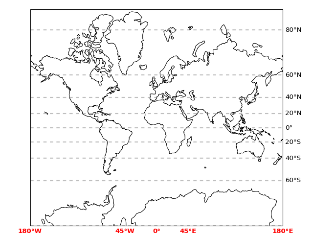
The following contrived example makes use of many of the features of the Gridliner class to produce customized gridlines and tick labels:
import matplotlib.pyplot as plt
import matplotlib.ticker as mticker
import cartopy.crs as ccrs

from cartopy.mpl.gridliner import LONGITUDE_FORMATTER, LATITUDE_FORMATTER


ax = plt.axes(projection=ccrs.Mercator())
ax.coastlines()

gl = ax.gridlines(crs=ccrs.PlateCarree(), draw_labels=True,
                  linewidth=2, color='gray', alpha=0.5, linestyle='--')
gl.xlabels_top = False
gl.ylabels_left = False
gl.xlines = False
gl.xlocator = mticker.FixedLocator([-180, -45, 0, 45, 180])
gl.xformatter = LONGITUDE_FORMATTER
gl.yformatter = LATITUDE_FORMATTER
gl.xlabel_style = {'size': 15, 'color': 'gray'}
gl.xlabel_style = {'color': 'red', 'weight': 'bold'}

plt.show()
