Cartopy projection list#
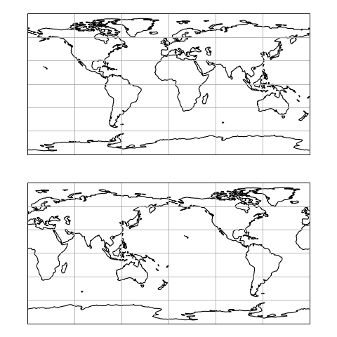
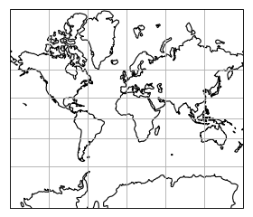
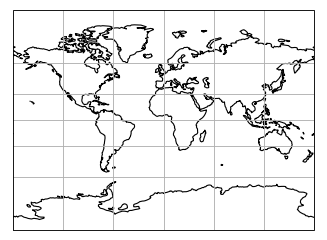
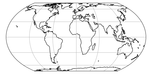
PlateCarree#
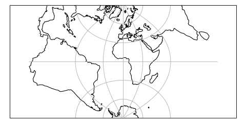
AlbersEqualArea#
- class cartopy.crs.AlbersEqualArea(central_longitude=0.0, central_latitude=0.0, false_easting=0.0, false_northing=0.0, standard_parallels=(20.0, 50.0), globe=None)[source]#
An Albers Equal Area projection
This projection is conic and equal-area, and is commonly used for maps of the conterminous United States.
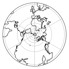
AzimuthalEquidistant#
- class cartopy.crs.AzimuthalEquidistant(central_longitude=0.0, central_latitude=0.0, false_easting=0.0, false_northing=0.0, globe=None)[source]#
An Azimuthal Equidistant projection
This projection provides accurate angles about and distances through the central position. Other angles, distances, or areas may be distorted.
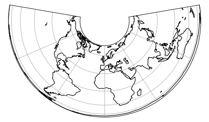
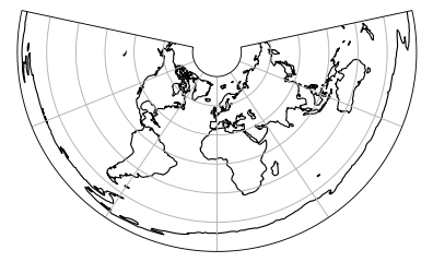
EquidistantConic#
- class cartopy.crs.EquidistantConic(central_longitude=0.0, central_latitude=0.0, false_easting=0.0, false_northing=0.0, standard_parallels=(20.0, 50.0), globe=None)[source]#
An Equidistant Conic projection.
This projection is conic and equidistant, and the scale is true along all meridians and along one or two specified standard parallels.
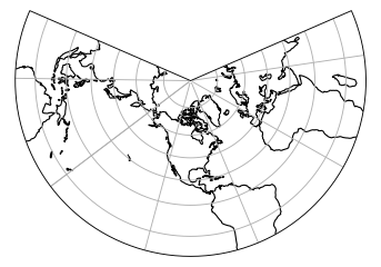
LambertConformal#
- class cartopy.crs.LambertConformal(central_longitude=-96.0, central_latitude=39.0, false_easting=0.0, false_northing=0.0, standard_parallels=(33, 45), globe=None, cutoff=-30)[source]#
A Lambert Conformal conic projection.
LambertCylindrical#
Mercator#
- class cartopy.crs.Mercator(central_longitude=0.0, min_latitude=-80.0, max_latitude=84.0, globe=None, latitude_true_scale=None, false_easting=0.0, false_northing=0.0, scale_factor=None)[source]#
A Mercator projection.
Miller#
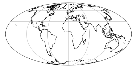
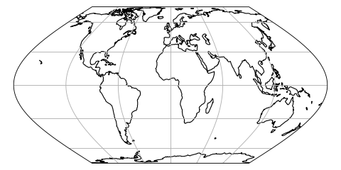
Mollweide#
- class cartopy.crs.Mollweide(central_longitude=0, globe=None, false_easting=None, false_northing=None)[source]#
A Mollweide projection.
This projection is pseudocylindrical, and equal area. Parallels are unequally-spaced straight lines, while meridians are elliptical arcs up to semicircles on the edges. Poles are points.
It is commonly used for world maps, or interrupted with several central meridians.
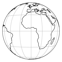
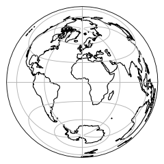
Orthographic#
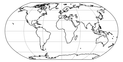
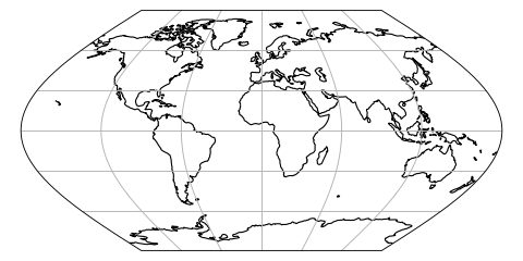
Robinson#
- class cartopy.crs.Robinson(central_longitude=0, globe=None, false_easting=None, false_northing=None)[source]#
A Robinson projection.
This projection is pseudocylindrical, and a compromise that is neither equal-area nor conformal. Parallels are unequally-spaced straight lines, and meridians are curved lines of no particular form.
It is commonly used for “visually-appealing” world maps.
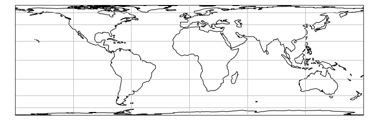
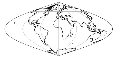
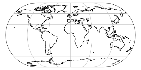
Sinusoidal#
- class cartopy.crs.Sinusoidal(central_longitude=0.0, false_easting=0.0, false_northing=0.0, globe=None)[source]#
A Sinusoidal projection.
This projection is equal-area.
Stereographic#
- class cartopy.crs.Stereographic(central_latitude=0.0, central_longitude=0.0, false_easting=0.0, false_northing=0.0, true_scale_latitude=None, scale_factor=None, globe=None)[source]#
TransverseMercator#
- class cartopy.crs.TransverseMercator(central_longitude=0.0, central_latitude=0.0, false_easting=0.0, false_northing=0.0, scale_factor=1.0, globe=None, approx=False)[source]#
A Transverse Mercator projection.
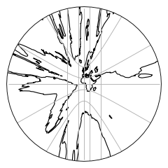
UTM#
- class cartopy.crs.UTM(zone, southern_hemisphere=False, globe=None)[source]#
Universal Transverse Mercator projection.
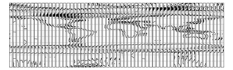
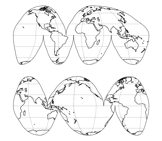
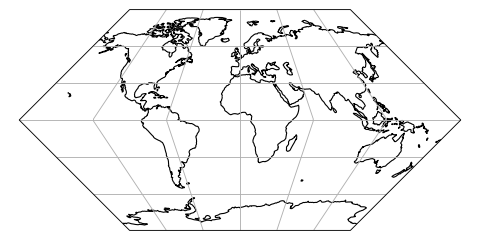
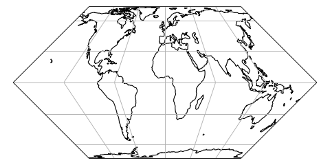
InterruptedGoodeHomolosine#
- class cartopy.crs.InterruptedGoodeHomolosine(central_longitude=0, globe=None, emphasis='land')[source]#
Composite equal-area projection empahsizing either land or ocean features.
- Original Reference:
Goode, J. P., 1925: The Homolosine Projection: A new device for portraying the Earth’s surface entire. Annals of the Association of American Geographers, 15:3, 119-125, DOI: 10.1080/00045602509356949
A central_longitude value of -160 is recommended for the oceanic view.
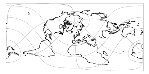
RotatedPole#
- class cartopy.crs.RotatedPole(pole_longitude=0.0, pole_latitude=90.0, central_rotated_longitude=0.0, globe=None)[source]#
A rotated latitude/longitude projected coordinate system with cylindrical topology and projected distance.
Coordinates are measured in projection metres.
The class uses proj to perform an ob_tran operation, using the pole_longitude to set a lon_0 then performing two rotations based on pole_latitude and central_rotated_longitude. This is equivalent to setting the new pole to a location defined by the pole_latitude and pole_longitude values in the GeogCRS defined by globe, then rotating this new CRS about it’s pole using the central_rotated_longitude value.
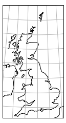
OSGB#
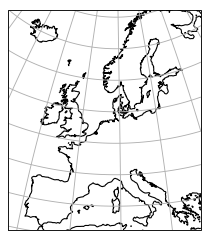
EuroPP#
- class cartopy.crs.EuroPP[source]#
UTM Zone 32 projection for EuroPP domain.
Ellipsoid is International 1924, Datum is ED50.
Geostationary#
- class cartopy.crs.Geostationary(central_longitude=0.0, satellite_height=35785831, false_easting=0, false_northing=0, globe=None, sweep_axis='y')[source]#
A view appropriate for satellites in Geostationary Earth orbit.
Perspective view looking directly down from above a point on the equator.
In this projection, the projected coordinates are scanning angles measured from the satellite looking directly downward, multiplied by the height of the satellite.
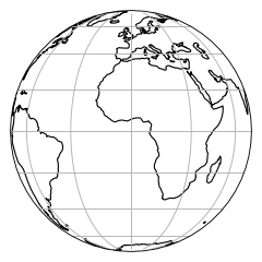
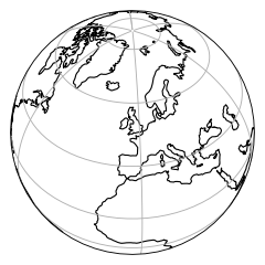
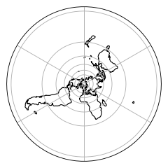
NearsidePerspective#
- class cartopy.crs.NearsidePerspective(central_longitude=0.0, central_latitude=0.0, satellite_height=35785831, false_easting=0, false_northing=0, globe=None)[source]#
Perspective view looking directly down from above a point on the globe.
In this projection, the projected coordinates are x and y measured from the origin of a plane tangent to the Earth directly below the perspective point (e.g. a satellite).
EckertI#
- class cartopy.crs.EckertI(central_longitude=0, false_easting=None, false_northing=None, globe=None)[source]#
An Eckert I projection.
This projection is pseudocylindrical, but not equal-area. Both meridians and parallels are straight lines. Its equal-area pair is
EckertII.
EckertII#
- class cartopy.crs.EckertII(central_longitude=0, false_easting=None, false_northing=None, globe=None)[source]#
An Eckert II projection.
This projection is pseudocylindrical, and equal-area. Both meridians and parallels are straight lines. Its non-equal-area pair with equally-spaced parallels is
EckertI.
EckertIII#
- class cartopy.crs.EckertIII(central_longitude=0, false_easting=None, false_northing=None, globe=None)[source]#
An Eckert III projection.
This projection is pseudocylindrical, but not equal-area. Parallels are equally-spaced straight lines, while meridians are elliptical arcs up to semicircles on the edges. Its equal-area pair is
EckertIV.
EckertIV#
- class cartopy.crs.EckertIV(central_longitude=0, false_easting=None, false_northing=None, globe=None)[source]#
An Eckert IV projection.
This projection is pseudocylindrical, and equal-area. Parallels are unequally-spaced straight lines, while meridians are elliptical arcs up to semicircles on the edges. Its non-equal-area pair with equally-spaced parallels is
EckertIII.It is commonly used for world maps.
EckertV#
- class cartopy.crs.EckertV(central_longitude=0, false_easting=None, false_northing=None, globe=None)[source]#
An Eckert V projection.
This projection is pseudocylindrical, but not equal-area. Parallels are equally-spaced straight lines, while meridians are sinusoidal arcs. Its equal-area pair is
EckertVI.
EckertVI#
- class cartopy.crs.EckertVI(central_longitude=0, false_easting=None, false_northing=None, globe=None)[source]#
An Eckert VI projection.
This projection is pseudocylindrical, and equal-area. Parallels are unequally-spaced straight lines, while meridians are sinusoidal arcs. Its non-equal-area pair with equally-spaced parallels is
EckertV.It is commonly used for world maps.
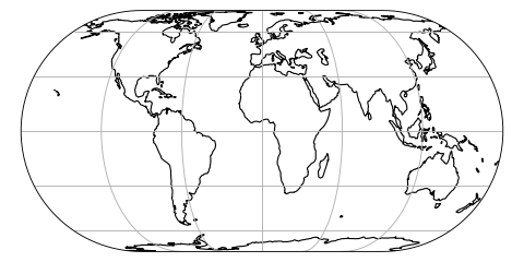
EqualEarth#
- class cartopy.crs.EqualEarth(central_longitude=0, false_easting=None, false_northing=None, globe=None)[source]#
An Equal Earth projection.
This projection is pseudocylindrical, and equal area. Parallels are unequally-spaced straight lines, while meridians are equally-spaced arcs.
It is intended for world maps.
Note
To use this projection, you must be using Proj 5.2.0 or newer.
References
Bojan Šavrič, Tom Patterson & Bernhard Jenny (2018) The Equal Earth map projection, International Journal of Geographical Information Science, DOI: 10.1080/13658816.2018.1504949
Gnomonic#
LambertAzimuthalEqualArea#
- class cartopy.crs.LambertAzimuthalEqualArea(central_longitude=0.0, central_latitude=0.0, false_easting=0.0, false_northing=0.0, globe=None)[source]#
A Lambert Azimuthal Equal-Area projection.
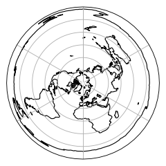
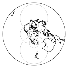
NorthPolarStereo#
- class cartopy.crs.NorthPolarStereo(central_longitude=0.0, true_scale_latitude=None, globe=None)[source]#
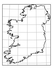
OSNI#
SouthPolarStereo#
- class cartopy.crs.SouthPolarStereo(central_longitude=0.0, true_scale_latitude=None, globe=None)[source]#