
Version 0.18 (May 3, 2020)#
For a full list of included Pull Requests and closed Issues, please see the 0.18 milestone.
Features#
We are very pleased to announce that Greg Lucas has been added to the cartopy core development team. Greg (@greglucas) added the NightShade feature in the previous release, and has been instrumental in issue and PR triage leading up to 0.18. He has also ensured that CI systems have kept working through various upstream project changes.
Kevin Donkers and Phil Elson made the AdaptiveScalar the default for Natural Earth Features. This will make the default features look much nicer when plotting on zoomed in axes. (PR #1105)
Elliott Sales de Andrade added support for Matplotlib 3.2 and 3.3 (PR #1425) and Python 3.7 and 3.8 (PR #1428).
Alan Snow added the ability to use Proj version 6.x (PR #1289) and Elliott Sales de Andrade updated a lot of the tests and build issues for this upgrade (PR #1417).
Andrew Huang added the ability to put the meridian and parallel gridline labels on the gridlines within the plot boundaries rather than only as labels on the boundary. (PR #1089)
Stephane Raynaud added longitude and latitude labeling to all projections. It was previously restricted to the Mercator and PlateCarree projections. (PR #1117)
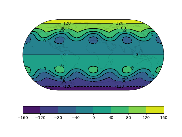
Phil Elson added the (long awaited!) ability to label contours on GeoAxes. A Contour labels example has been added to the gallery demonstrating the new capability. (PR #1257)
Matthew Bradbury added the ability to query UK Ordnance Survey image tiles. (PR #1214)
Phil Elson added the ability to fetch image tiles using multiple threads. (PR #1232)
Elliott Sales de Andrade added a
cartopy.mpl.geoaxes.GeoSpineclass to replace thecartopy.mpl.geoaxes.GeoAxes.outline_patchthat defines the map boundary. (PR #1213)Elliott Sales de Andrade improved appearance of plots with tight layout. (PR #1213 and PR #1422)
Ryan May fixed the Geostationary projection boundary so that geometries no longer extend beyond the map domain. (PR #1216)
Phil Elson added support for style composition of Features. This means that the styles set on a Feature when it is created, and when it is added to an Axes, will be processed consistently.

Deprecations#
This will be the last release with Python 2 support.
The default value for the
originargument tocartopy.mpl.geoaxes.GeoAxes.imshow()is now'upper'to match the default in Matplotlib.The
cartopy.mpl.geoaxes.GeoAxes.outline_patchattribute is deprecated. In its place, use Matplotlib’s standard options for controlling the Axes frame, or accessGeoAxes.spines['geo']directly.The
cartopy.mpl.geoaxes.GeoAxes.background_patchattribute is deprecated. In its place, use Matplotlib’s standard options for controlling the Axes patch, i.e., pass values to the constructor or accessGeoAxes.patchdirectly.The gridliner labelling options
cartopy.mpl.gridliner.Gridliner.xlabels_top,cartopy.mpl.gridliner.Gridliner.xlabels_bottom,cartopy.mpl.gridliner.Gridliner.ylabels_left, andcartopy.mpl.gridliner.Gridliner.ylabels_rightare deprecated. Instead, usecartopy.mpl.gridliner.Gridliner.top_labels,cartopy.mpl.gridliner.Gridliner.bottom_labels,cartopy.mpl.gridliner.Gridliner.left_labels, orcartopy.mpl.gridliner.Gridliner.right_labels.